


وصف لـ OSM Peak Finder
The app is programmed just for fun in free time with no commercial purpose. The feedback is always welcome as well as any suggestions for improvements.
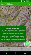
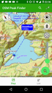
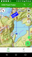
The main functionality is to present the mountain peaks near your location. Using the bearing line, which is showed starting at your location, you will be able easily to localize and identify peaks around you.
The map tails can be pre-loaded as well as the peak's information, so it should also be possible if you are online, assumed you loaded it before being online.
With the seek bar you can also filter out peaks starting with certain elevation.
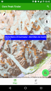
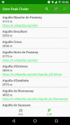
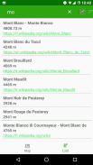
You can also show the list of the surrounding peaks and e.g. sort them by elevation or name. In the list you will also additional information such as link to Wikipedia, if available or disability access.
Have fun using it and let me know if you like it.
تتم برمجة التطبيق للمتعة فقط في وقت الفراغ دون أي غرض تجاري. ردود الفعل هي دائما موضع ترحيب وكذلك أي اقتراحات للتحسينات.
الوظيفة الرئيسية هي تقديم قمم الجبال بالقرب من موقعك. باستخدام خط المحامل ، الذي يتم عرضه بدءًا من موقعك ، ستتمكن بسهولة من تحديد القمم المحيطة بك والتعرف عليها.
يمكن تحميل ذيول الخريطة مسبقًا بالإضافة إلى معلومات الذروة ، لذلك يجب أن يكون ذلك ممكنًا إذا كنت متصلاً بالإنترنت ، على افتراض أنك قمت بتحميلها قبل الاتصال بالإنترنت.
مع شريط البحث ، يمكنك أيضًا تصفية القمم بدءًا من ارتفاع معين.
يمكنك أيضًا عرض قائمة القمم المحيطة وعلى سبيل المثال فرزها حسب الارتفاع أو الاسم. في القائمة ، ستقوم أيضًا بمعلومات إضافية مثل رابط ويكيبيديا ، إذا كان ذلك متاحًا أو الوصول إلى الإعاقة.
استمتع باستخدامه واسمحوا لي أن أعرف إذا كنت ترغب في ذلك.
OSM Peak Finder - إصدار 1.02.67
(25-02-2024)OSM Peak Finder - معلومات APK
نُسخة APK: 1.02.67الحزمة: eu.wuwer.osmpeakfinderتطبيقات من الفئة نفسها
قد يعجبك أيضًا...


